September 14th, 2002
|
September 14th, 2002
|
|
About The World's Toughest Century Ride
|
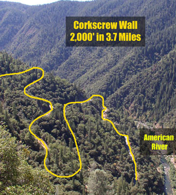
This will be the most scenic and inspiring bike ride of your life! You will travel on an exhilarating route over remote logging and forest service roads, virtually free from busy highway traffic. You will repeatedly climb and descend breathtaking river canyons as you complete the large loop through the western slope of the Sierra Nevada's. You will pass through historic gold rush towns, wild rivers and tributaries of the American River watershed, glorious forests teeming with wildlife, pristine Alpine lakes and face some of the toughest climbs imaginable - steeper than anything found in notorious Tour de France routes like Alpe D'Huez. The Century loop is 105+ miles, with 12,300ft of climbing. A highlight of the ride is the infamous Corkscrew Wall begins with a climb from the Oxbow Reservoir (Middle Fork, American River) right up the canyon wall with few switchbacks. Grinding up this ~15% initial grade, fully exposed to the heat of the canyon, you will need a 39 x 28 to keep your bike upright! After a brief respite, the road winds upward in a corkscrew pattern to the crest of Ralston Ridge, 2,000 feet above the canyon floor in only 3.7 miles. This remarkable road is clearly visible from the air as it falls in a common flight path of commercial jets heading to Sacramento. Is this ride too tough for me? The Century Loop will offer plenty of climbing, but with proper gearing, you can get up any hill. The weather (outside of the deep canyons) is temperate in September and the moderate altitude will not inhibit your performance. These factors, along with the fresh, energizing mountain air and the extensive aid along the route, will allow your body to perform at its peak! The connection with nature you experience covering such extensive ground across the Sierra will be an unforgettable experience.
|
Century Loop - Route Description
| The ride begins at the Auburn Dam Overlook, right on the
edge of the American River Canyon on the Southern edge of Auburn city
limits. The ride will proceed through residential neighborhoods through the
town of Auburn, climbing steadily east until we reach Foresthill Road - a
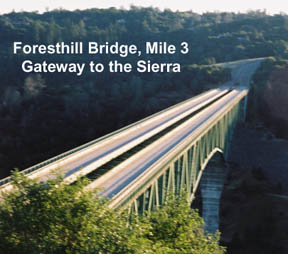
prominent exit off of Interstate 80. A quick descent of several hundred feet
takes you to the beginning of the amazing Foresthill Bridge, the second
highest bridge in the United States with a 700-foot drop to the American
River below.
Across the bridge, you begin a long, gradual climb up the Foresthill Divide for 15 miles to the town of Foresthill. You climb from ~1,200' at the bridge to Foresthill at 3,225'. The road is recently widened with a nice shoulder and smooth pavement all the way to Foresthill. There are numerous sneaky steep climbs of 2-5 minutes, interspersed by flat to downhill stretches. Pine trees line the road for nice shade and scenery. |
 |
| About a mile before proper downtown Foresthill, you will
reach Worton's Market on your side of the road. The parking lot offers an
expansive view of the Sierras and the Tahoe ridgeline. About 1/2 mile past
that, you will turn off on Mosquito Ridge Road and begin a gradual 12-mile
descent to the American River. Locals can point out a fresh water spring
along the way, as well as an entrance to a large gold mine tunnel, still
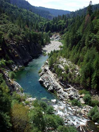
being used by local miners. There is a false bottom where you will cross the famous Circle Bridge (BMW filmed a flash video for their web site there) over a river fork and then tackle a 400' climb. Soon after the crest of the climb, you will turn on an obscure, narrow road and descend to Oxbow Reservoir. Use extreme caution as the road is extremely steep and windy. Oxbow, the starting point for Middle Fork river rafting trips, is surrounded by massive canyon walls on all sides.
|
| After crossing a small bridge at the bottom you will see the mile 32 aid station. Fuel up for a long journey into the mountains ahead! At this point, the road runs right alongside Oxbow - look down into the clear water and you can see fish swimming! The sightseeing soon ends as you leave the reservoir edge and proceed to the foot of the Corkscrew Wall. Gear down for this relentless 4-mile ascent out of the canyon - an elevation gain of over 2,000 feet! | 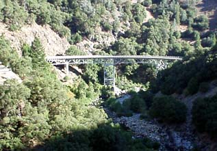 |
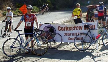 After climbing out the canyon wall with very few switchbacks, you will reach a false top followed by a slight descent that turns away from the river canyon. The fun continues as you reach the corkscrew portion of the road - a swirling climb that takes you to the beginning of Ralston Ridge. Enjoy the sweeping views of the Sierra from the ridgeline. In just a few miles, you have gone from being in a deep river canyon to the ridge. |
 |
|
Heading East for several miles on the ridge, you will hit a series for forks to the right as you make your way South towards the Rubicon river canyon. First turn is onto Blacksmith Flat Rd at 41 miles then at Ramsey Crossing at 46 miles then 11 Pines Rd at 49miles (Century loop). There are several sneaky little river canyons that you climb in and out of before making a long descent to the Rubicon River. The climb out of the Rubicon registers the most complaints on the loop! For Iowa Hill or the Corkscrew Wall, you are fresh and psyched for the challenge. By the 60-mile point (95-mile Superstar), your legs have been worked by repeated climbing and descending and you face a long, steady climb out of the Rubicon up to Wentworth Springs Rd near Uncle Tom's Cabin. The climb is 5 miles and 1,500' at a steady grade. When you reach the top, you are rewarded with essentially a 35-mile cruise down the ridge.
|
 |
|
The 24-mile stretch from Uncle Tom's to Georgetown features the beautiful Stumpy Meadows lake and numerous little towns that date their history back to the Gold Rush. This area is known as the Georgetown divide. Landmarks from the beginning of Wentworth Springs Rd (top of Rubicon climb) are Stumpy Meadows lake, Quintette, Camp Virner, Buckeye and finally the historic Gold Rush town of Georgetown. In 24 miles you have descended from 5,000' to 2,400' in Georgetown. Out of Georgetown you take state highway 193 12 miles to Cool. You immediately encounter a quick climb - quite a shock to your descending legs. After a very fast 2-mile downhill, you will ride 8-miles of flats and rolling hills. The prevailing wind is in your face so this can be a tough stretch. Finally, you arrive in Cool and proceed down highway 49 to the American River confluence below Auburn. This is a 3.5-mile descent (one little climb) and is quite a busy road. Please use caution descending this steep, windy canyon. At the bottom of the canyon, you reach the confluence of the North fork and Middle fork of the American Rivers. This is a popular recreation area for Auburn locals and Sierra travelers. You will begin your final 2.3-mile climb on Highway 49 to Auburn. This is a busy canyon road with little shoulder at times. Motorists will be alerted with signs and ride staff to beware of cyclists, but please use caution climbing out of the canyon. If you are extremely concerned, you may take a detour that adds 5.5 miles to your journey. Just take a right at the road fork across the Highway 49 bridge and onto the remote Old Foresthill Rd. This roundabout way involved climbing Old Foresthill Rd (3.5 mi) to Foresthill Rd (3 miles) to top of Auburn and then descending 3 miles to the Overlook. You may not be in the mood to add 5.5 miles at that time in your ride, but you will be after and you get to ride again across the breathtaking Foresthill bridge. |
© Roland Wooster, 2007. All rights reserved.